Route 66

Two Guns Arizona – Route 66
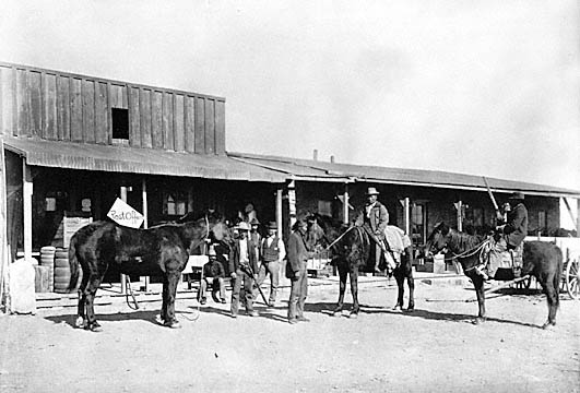
Alot of History Here in Two Guns

With the exception of the wigwam motel in Holbrook, the thing that was most on my mind this entire trip was stopping to take pictures of Two Guns.   I’ve seen it before, but only from the freeway and the off ramp.   For years and years, there was a caretaker there with a buck knife and a shotgun that would speed up in his 4 wheeler if you got anywhere close to Two Guns ruins he’d show up and yell you off the property.   He was pretty well known for being efficient and serious about what he does.   Two guns has been bought and sold several times and my information tells me he was hired to protect the property from vandals.  As of 2008, I’d heard he was gone, so I’ve always wanted to come back here.
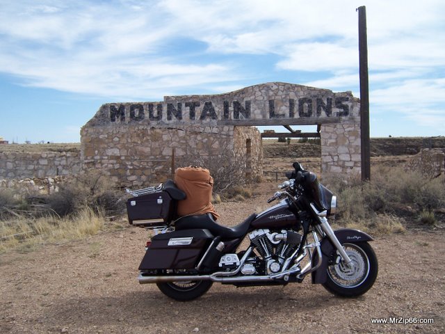
Street Glide at Two Guns Arizona
Street Glide at Two Guns Arizona - This ruin is the 2nd of Two Zoos in Twin Gun's History.

Two guns has an impressive history and to the casual, modern passer by, you’d never know it.     From the Indian wars between the Apache and the Navajo (it was then known as Canyon Diablo, or Devil’s Canyon, to the Early days of National Trails Highway (pre-Route 66) to Today.    Many people believe it is cursed, and for good reason.    Lots of battles here, and it held the distinction of being the roughest town in the west, let alone Arizona.    Murder, Prostitution, At least a punch in the face for looking at someone wrong.   Two Guns is the shit.  If you want the complete history of two guns, I’d highly suggest reading this link here.
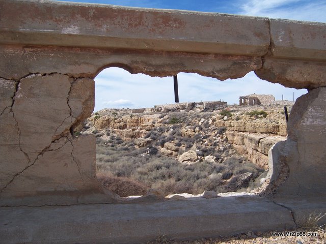
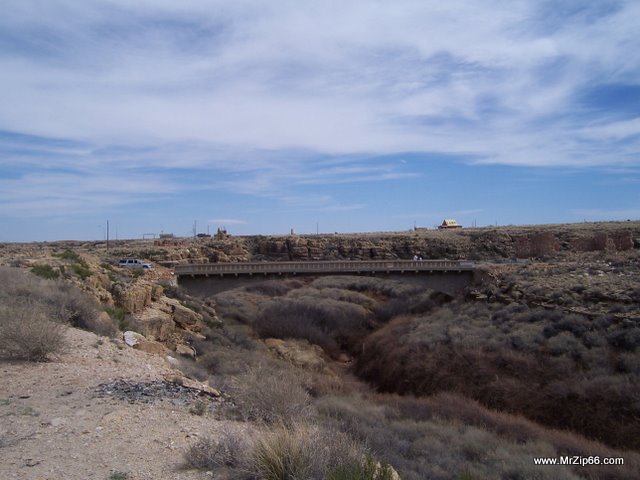
Canyon Diablo Bridge is Crumbling

I had a chance to FINALLY cross the bridge that I’d seen for years, and even as I type this I regret not driving it down the dirt road further, because as I passed it all down 1-40 I realized there was much more I missed.   I was able to see the more modern abandoned gas station, and the slightly older KOA campground, as well as the other ruins.    There is also a very deep cave that factored into its rich history of a cowboy town.   Pat, are you reading this???  We need to go back to two guns and spend a day.
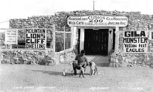
Picture of the First Zoo at Two Guns Arizona
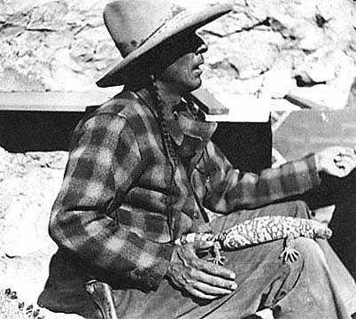
Harry E. (Indian) Miller Ran Two Guns from 1925 to 1935

I hope no jackasses out there vandalize Two Guns, because it really needs to be preserved.    It’s cool that we can visit two guns now, But please if you visit it leave it as it is.  There’s not many people I hate worse than a Vandal.     This town burned down TWICE and survived history like no other, and is now just a side glance to people heading to Flagstaff and Albuquerque.    I think we all need to help keep it alive as long as possible.   Theres enough route 66 out there thats rotting, we don’t need this one to rot anymore than what nature throws at it.

Canyon Diablo  Bridge
Canyon Diablo Bridge

There is also a huge railroad trellis around two guns somewhere that crossed the canyon.   It’s clear I need to go back untill I know ALL the stories associated with this great historic spot in the road.    Two Guns.   read that link.   This may be one of my favorite Route 66 spots yet.    It’s full of history and full of questions to be answered.

[nggallery id=12]

Two Guns Arizona – Route 66 Read More »

Meteor City Route 66

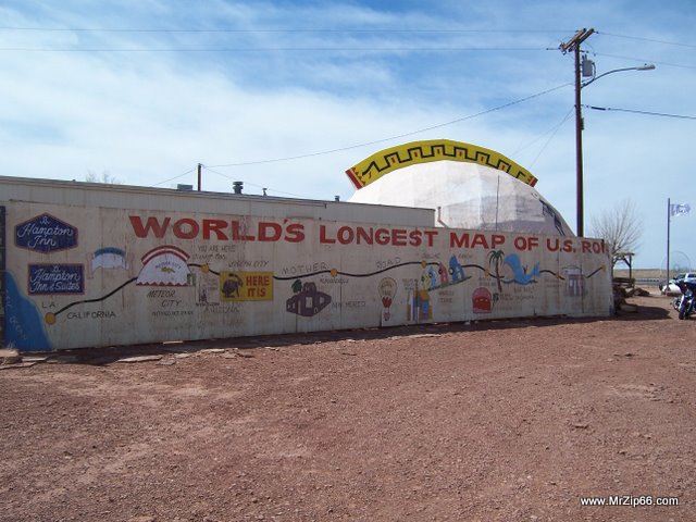
I knew I had things I wanted to see on this trip, particularly Two Guns and Twin Arrows, so after Joseph City I opened up and headed toward winslow.    I’ll admit my knowledge of route 66 winslow is pretty meager, and I found myself just passing it altogether to head toward Two Guns.   I totally forgot about meteor city, so I pulled over to see it.   Meteor City is the home of the worlds longest map of route 66, and thats the trading posts biggest claim to fame.

The original trading post was built in 1938 and was made out of stucco.   The current geo-dome was built in 1979.   I’m a bit resistant to moccassins and native american blankets, but the histories on the walls are alot more interesting.

Meteor City.
Meteor City.

The orignal mural was painted by Bob Waldmire, if you know who he is.   He’s a famous wandering resident of route 66 and unofficially its favorite artist.    The original mural eventually weathered away, and in 2002 it was repainted.   Not alot to see here, and after 10 minutes I headed west to Two Guns.

[nggallery id=13]

Meteor City Route 66 Read More »

Joseph City & Jack Rabbit Trading Post on Route 66

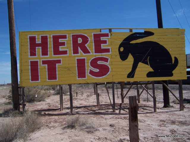
Here it is!  A Route 66 Icon
Here it is! A Route 66 Icon

Most of Interstate 40 covers up old route 66 pavements, but when the frontage road doesn’t exactly parallel the freeway, much of the time you can bet it’s old 66.    Joseph city is one of those alignments, and I was looking foward to seeing  Joseph City before it ended in Gravel and disappeared under the super slab of Interstate 40.

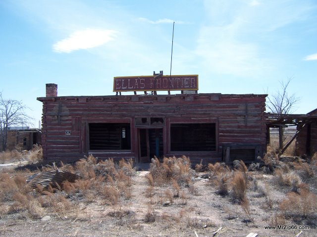
I had suspicions that joseph city was named after Joseph Smith, the founder of the mormon religion, and turns out I was right.   I didn’t see a whole lot there that was interesting, other than on the far edge of town on the old route:   Ella’s Frontier:

Ellas Frontier - Original Route 66 Trading Post

I’d never seen Ellas Frontier on any of my route 66 books, or at least I hadn’t noticed them.   I’d love to know the story of when it was opened and when it closed.   ANYTHING.    A few web sites state that Ellas frontier was the first trading post on route 66, but that seems pretty unlikely to me.   Who knows, I’ve been wrong before.   Either way, it was a pretty cool old building.   In the back next to the freeway it had what looked like cabins, and had an old Camping spot next door that looked somewhat newer, but still abandoned.     Ellas is the kind of place that I’ll want to go back and take a closer look on my next trip.   Theres definately stories in those walls.    Please, if you know anything about this place, please post or email me.

From Ellas I doubled back and got onto the freeway to head down to the next exit to see the Jack Rabbit Trading post.   I love the old signs and have been here once before.    The place was clean, the owner friendly and the prices were great.   Most people sell T-shirts for 20 bucks.   He sells his for 10, and has a ton.   He even sells Jack Rabbit Underwear.   Awesome.   It was good to see such an old road icon doing well.   I’d read that it was gone, but I saw no signs of anything other than a trading post that was doing well.

Jack Rabbit Trading Post was started in 1949 by Jim Taylor and his wife. He leased the business for most of the years he had it. Cindy’s granddad, Glenn Blansett, leased the store in 1961 and then bought it in 1967. He was just getting out of the senate so we were lucky for that because he helped to get the access ramps off I-40. In 1969, Cindy’s parents, Phil and Pat Blansett bought the Jack Rabbit from Cindy’s granddad. They had the store for 26 years. Until Tony and Cindy bought it from them in 1995.


I bought a half pint of tennesee whisky from him for 3 bucks for later and headed down the road.   It was noon.   I had half the state to cross yet.

Joseph City Gallery:

[nggallery id=15]

Jack Rabbit Trading Post Gallery:

[nggallery id=16]

Joseph City & Jack Rabbit Trading Post on Route 66 Read More »

Holbrook Arizona's Wigwam Motel – Route 66

The Beeline Highway
The Beeline Highway

Finally.   I had 2 days to ride.   what seemed like the longest winter of my life is about over.   Over enough that I can load up my bike and sleep in the freezing cold if I need to, but at least I’m RIDING.

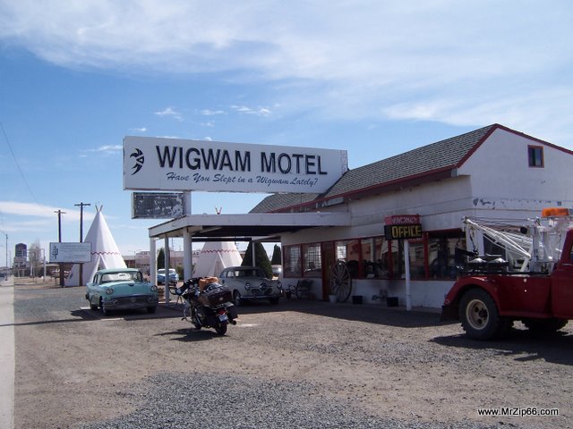
I couldn’t sleep all night.   I finally got going around 7AM to load up my bike and head out of chandler, leaving Robyn and the kids to play in the pool all day and go shopping while I pointed my bike toward Holbrook.    The weather was great, but got chilly as I climbed into Payson and the mountains of Heber, then finally down into Holbrook.    Holbrook is as far east as I’ve ever been on route 66, and I had to see what I think is an icon of the mother Road:  The wigwam Motel

Have you slept in a wigwam Lately?

Built in 1950 by Arizona motel owner Chester E. Lewis, the plans were based on the original of Frank A. Redford.

Lewis first became aware of the distinctive wigwam designs when he was passing through Cave City in 1938. He purchased the rights to Redford’s design, as well as the right to use the name “Wigwam Village” in a novel royalty agreement: coin operated radios would be installed in Lewis’ Wigwam Village, and every dime inserted for 30 minutes of play would be sent to Redford as payment.

Lewis operated the motel successfully until closing it in 1974 when Interstate 40 bypassed downtown Holbrook. Two years after his death in 1986, sons Clifton and Paul Lewis and daughter Elinor renovated the motel, finally reopening it in 1988.

Fifteen concrete and steel teepees are arranged as a square with one edge missing where the main office is located. They are numbered from 1 to 16 (there is no teepee 13). The diameter of the base of each teepee is 14 feet (4.3 m), with each unit 32 feet (9.8 m) in height. Behind the main room of each unit is a small bathroom with sink, toilet, and shower. Current rooms contain the original restored hickory furniture, two double beds, cable TV and a window mounted air conditioner; there are no telephones or Internet access. Vintage restored automobiles from the 1960’s and earlier are located throughout the parking area. Small green metal benches etched with the words “Wigwam Village #6” are scattered throughout the complex as well.

The Lewis family continues to run and maintain Wigwam Village #6. Elinor often shows up at 4:00 pm to open the office, and if requested, will fill a small ice bucket (there is no ice machine in keeping with the authenticity of the restoration) for customers. Near the registration desk is a small room which contains many of Chester Lewis’ memorabilia (including a necklace of human teeth of unknown origin).

Nearby places of interest include Petrified Forest National Monument and Meteor Crater (Barringer Crater). Wigwam Village #6 was featured in the second episode of Oprah and Gayle’s Big Adventure on Oprah’s TV show. It is located on Historic Route 66, 811 West Hopi Drive, Holbrook, Arizona.

It was still early, and I’d intented on meeting the owners to pitch them a web site in trade for letting me stay at there for free (Holbrook is a perfect place to start a route 66 journey east from St. George), but they open late so I headed west.

[flashgallery]

Holbrook Arizona's Wigwam Motel – Route 66 Read More »

Route 66 with Wendy

This weekend, it was just nice. All day friday I was kicking around thoughts of heading somewhere to get some ride time in, and around 3 on friday I came home, and asked if Wendy wanted to go. She did. Headed out around 3.

Wendy is a pro. Last year we loaded up and rode to Universal Studios on the bike in the heat of the summer, and she was a blast to take. Doesnt complain, and loves riding. I love the one on one time. I didnt have a ton of one on one trips with my Dad, and the one I did always meant alot to me. Its one of the reasons I bought the bike. I hope its a memory that means something to my girls. Not alot of 11 year olds can say theve ridden thousands of miles on a harley davidson and seeing their world. Thats my delusion anyway. We’ll see.

Wendy, at hoover Dam. Friday, May 16 2008

Made kingman before dark.

Wendy loves Hotels. She played her DS and even talked me into going swimming for a few. We crashed that night, and woke up to get some road behind us.

Kingman is a cool town to me for some reason. Its got alot of route 66 flavor, and its got all the modern conveniences. Plus its a gateway to alot of my favorite roads. to the east is Seligman, and a great old stretch of 66. the west is a great bike road through oatman, and california. I like to ride for kingman and decide which way Im going to go when Im at the intersection, and its usually always a great ride.

for the sake of time we went to oatman. Wendy had never seen it, and I thought she might like it. We headed out, and took the winding road up to oatman. There was a live wedding in the street, which was kind of cool to see. Ive seen a few gunfight shows, but not a wedding.

Oatman is one of the most unique towns, if not the most unique that I’ve ever seen. Around the turn of the century it was a booming mining town, and it still holds that feel. If it had a dirt street, I cant imagine a wild western town being much different. When the mines stopped producing, the miners left their burros and theyve thrived in the desert without any natural predators, and they still roam the streets.

Wendy found a ragged old cat, that apparantly liked to fight. His owner said he would leave for days and would come back all cut up, and would even take on coyotes and whoever crossed his path. Wendy made immediate friends. She has cat mojo. I even liked this cat.

Clark Gable and Carol lombard had their honeymoon at the oatman hotel. The hotel is a museum now, and we checked it out. Ive been to oatman a bunch, but that was the first time I’d been in the hotel. Theres even a tattoo shop there, but I didnt go in. Maybe I should check him out next time.

After about an hour of Oatman, we headed for the colorado river through Topock, then onto Needles. Wendy was beat. I made the mistake of not switching out a touring seat for my bike, and we both had a bad case of TB. We ate at dennys, and called Robyn to tell her we would head home. It was pretty hot, and Robyn and I had a Penguins NHL playoff game at 1pm, so I figured we’d head back. But I REALLY wanted to go to Amboy. Albert Okura had bought the town, and its one of my favorite spots on route 66, and a couple of weeks ago, they finally got the gas station open after a couple of years of work and about 750 grand. At the crossroads, I decided to spend another day, go to Amboy, and spend the night in Barstow.

Luckily, Ive got the best wife in the world. I called her and she got us a room in Barstow. We pulled in through record heat into Amboy and drank about a gallon of water and hung out for about an hour or so, resting our butts and hydrating up.

A tour bus overturned just east of ludlow, and eastbound highway was routed from I 40 down old 66. It was actually pretty cool to see Roy’s get so much business, and I couldnt help but thinking thats how it mustve been before it was bypassed in the early 70s. Even so, the one guy watching shop went out of his way to give Wendy a Roy’s T shirt for no charge, which I thought was really pretty cool. Ill always swing wide for Roys. Albert Okura paid 400k for the town. It’d be nice to have that kind of money, I’d like to own a town one day. Someday…..

We headed over to barstow, and just relaxed. Wendy was beat, and so was I. We woke up in the morning and made time to get back to st George, by 1pm, and made it. All in all, we’d rode 760 miles in less than 48 hours. Wendy is my riding buddy. I hope she had a good time. I know I did.

Ride Totals: 722 Miles, 4 States in 2 1/2 Days

[googlemaps http://maps.google.com/maps?f=d&hl=en&geocode=5460195716597490523,37.070312,-113.877478%3B13014085877754107342,36.242780,-114.516390%3B11101874023695939221,35.207280,-114.098580%3B11934177521479792722,35.028720,-114.385900%3B4745915673430077905,34.841580,-114.612180%3B4815941953477700613,34.643110,-115.378580%3B12907642574802950246,34.577006,-115.848759%3B990865054233882008,34.886060,-117.013170&saddr=Santa+Clara,+UT&daddr=Old+US-91+%4037.070312,+-113.877478+to:Northshore+Rd%2FNV-167+%4036.242780,+-114.516390+to:US-93+S+%4035.207280,+-114.098580+to:CR-153+%4035.028720,+-114.385900+to:I-40+W+%4034.841580,+-114.612180+to:National+Trails+Hwy+%4034.643110,+-115.378580+to:National+Trails+Hwy+%4034.577006,+-115.848759+to:I-40+W+%4034.886060,+-117.013170+to:37.155939,-113.631592&mra=mi&mrcr=4&mrsp=9&sz=8&via=1,2,4,6&sll=36.399178,-114.680786&sspn=2.051508,4.812012&ie=UTF8&s=AARTsJoSNz5eq8egVcXVva5pfH2GYF23eQ&ll=36.399178,-114.680786&spn=6.188317,9.338379&z=6&output=embed&w=425&h=350]

Route 66 with Wendy Read More »

Day 6: Route 66

Waking up in Kingman on Route 66We stayed at KOA in Kingman and headed out to my favorite stretch I’d been on yet. It wasn’t as deserty as the california stretch and the road was good. We stopped at Grand Canyon Caverns and at Seligman.

At Seligman I had the best burger I’ve ever had in my life at Juan Delgadillos Snow Cap. Juan is a nut. We took a walk down Seligman and found his brothers store, that had all sorts ofSnowball Palace, Grand Canyon Caverns route 66 stuff. We bought 2 T-shirts and a book, and talked for an hour or so. Seligman is a town that refuses to die, and it seems mostly due to the delgadillo brothers. Out of all the route 66 towns Amboy and Seligman seem to have the 66 spirit and wont let it die. The others don’t seem to care too much that I noticed, they were dealing with it.

Anyway, we took a few pictures and some info and left seligman. We passed the crooktown road exit and went into ash fork to get gas athe chevron station. Tried to find the road and bridge that was in the Rider magazine. We never found it. We crossed the railroad tracks, but I think we should’ve gone left instead of right. I was afraid of getting a hole in my tire, and wasnt all that sure it was, so we headed back through ash fork and said goodbye to route 66. On the way to williams, there was a really big abandoned stretch we noticed.Mummified Bobcat,  Grand Canyon Caverns

We went through Williams and the ride was great untill we got to the grand canyon. What a crowded tourist trap! We stayed just outside the park in Tusayan and it sucked. Windy, dirty and noisy. Helicopters constantly landing and taking off right next to the campground.

[googlemaps http://maps.google.com/maps?f=d&hl=en&geocode=17993792335159316445,35.527404,-113.432183%3B17089950981724175164,35.320728,-112.849290%3B1487652939200003640,35.967730,-112.129110&saddr=kingman+AZ&daddr=AZ-66+%4035.527404,+-113.432183+to:35.317366,-112.818604+to:US-180+%4035.967730,+-112.129110&mra=dme&mrcr=0&mrsp=2&sz=10&via=1,2&sll=35.290469,-112.723846&sspn=0.949413,1.463928&ie=UTF8&s=AARTsJrA2MgSicKspQazD69XdpZMPL18sQ&ll=35.541166,-112.994385&spn=1.564398,2.334595&z=8&output=embed&w=425&h=350]

Day 6: Route 66 Read More »

Day 5: First Day on Route 66

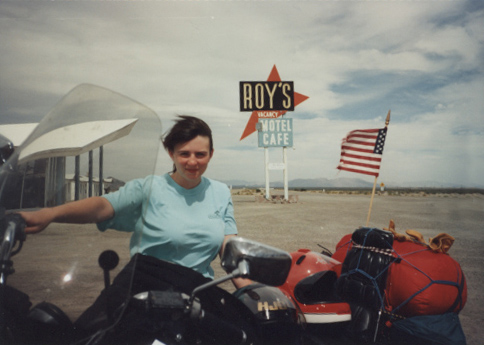
Robyn at Roys on Route 66
Robyn in 1991 at Roy's in Amboy

Rode 404 miles today.

We left Anaheim about 10, somewhat reluctantly. Disneyland for 2 days was a blast. We rode splash mountain 5 times (one of which I lost my watch on) and if the park wouldnt have closed at 10 instead of 1 AM like we thought, we wouldve probably done every ride twice. We could have spent a week there.

Anyway, we took highway 5 to 405, north on 55 onto 91 and then 1-15 North. We got off on a part of route 66 near Cajon pass. It was only about 8 miles but it already showed a few casualties of the interstate. It was once a two-laner and I think we missed a little of it and couldve found more. Then it was 1-15 through to Barstow. At Dagget, we found old trails highway, ol’ route 66 again. we went through newberry springs, a little town practically under the 1-40 underpass and stopped 30 miles later at ludlow to get a gatorade. 1/2 hour later, we were in Amboys at a place called Roys. Its owned by Buster Burris, who said he’d been there 50 years. He was rad! We ate, bought a T-shirt, talked for a while about route 66 and headed for cadiz or chambless to get gas. Then, we went through goffs, a shmeggy little place buster showed us that was the OLD route 66. Then it was to 1-40 untill we hit Topock. I know we missed alot of it.

We rode through Oatman, and old ghost town that had closed down by the time we got there, but did have a sarsparilla and headed out. Oatman and goldroad was pretty interesting. At one time it had 10,000 people and now it has 100 people…… maybe.

Rode into Kingman for the night to the KOA. Windy day, but a nice ride.

[googlemaps http://maps.google.com/maps?f=d&hl=en&geocode=7496869689303502543,33.832830,-117.919180%3B15118096633822049589,33.774681,-117.860081%3B2566601709567911381,34.253809,-117.459432%3B446161051617951934,34.347216,-117.468695%3B9071864067465498029,34.732010,-117.326530%3B2626768883307202373,34.885910,-117.029950%3B15563764665090701006,34.555420,-115.756240%3B11155277860971333610,34.828370,-115.051380%3B14065704722403104914,35.190600,-114.064000%3B7952691562820891419,35.021510,-114.382950&saddr=S+Harbor+Blvd+%4033.832830,+-117.919180&daddr=S+Parker+St+%4033.774681,+-117.860081+to:Cajon+Blvd+%4034.253809,+-117.459432+to:I-15+S+%4034.347216,+-117.468695+to:National+Trails+Hwy+%4034.732010,+-117.326530+to:I-15+N+%4034.885910,+-117.029950+to:National+Trails+Hwy+%4034.555420,+-115.756240+to:National+Trails+Hwy+%4034.828370,+-115.051380+to:35.029996,-114.375916+to:W+Beale+St+%4035.190600,+-114.064000+to:CR-153+%4035.021510,+-114.382950&mra=dpe&mrcr=2&mrsp=8&sz=9&via=1,2,3,4,7,8&sll=35.041241,-114.400635&sspn=1.904607,2.927856&ie=UTF8&s=AARTsJpGwnVIqVEYBVDpMe_xCbhcZ5vh9A&ll=34.660322,-116.026611&spn=3.162626,4.669189&z=7&output=embed&w=425&h=350]

Day 5: First Day on Route 66 Read More »